Topcon Positioning Systems announces additions to its geomatics portfolio designed to support integrated digital workflows for survey, construction, and infrastructure projects. The new solutions expand Topcon’s geospatial ecosystem, including reality capture, positioning, data management, monitoring, and subsurface intelligence technologies to improve accuracy and the flow of information on projects. The announcement was made in conjunction with INTERGEO 2026, the trade fair for geodesy, geoinformation, and land management, taking place September 15–17 in Munich, Germany.
This press release features multimedia. View the full release here: https://www.businesswire.com/news/home/20260914298196/en/
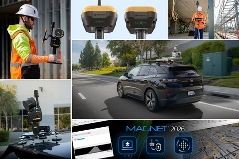
Topcon Positioning Systems announces additions to its geomatics portfolio designed to support integrated digital workflows for survey, construction, and infrastructure projects. The new solutions expand Topcon’s geospatial ecosystem, including reality capture, positioning, data management, monitoring, and subsurface intelligence technologies to improve accuracy and the flow of information on projects.
“Industry professionals are looking for flexible technologies that fit within their existing processes,” said Neil Vancans, head of Topcon Geomatics Sales. “Topcon addresses this need through open integrations, cross-platform compatibility, and connected workflows. We provide an ecosystem that helps users streamline processes, improve collaboration, and simplify the digital management of project data. These new solutions, together with continued AI integration, reflect our focus on practical, interoperable technologies for the geomatics industry.”
Additions to the Capture Reality portfolio of mass data solutions include:
- Topcon Origo is a spatial positioning system for interior building layout that supports the accurate placement of points according to project requirements. The system uses reference-map-based positioning and a fixed origin to maintain a consistent project reference while reducing reliance on the direct line of sight required by traditional optical or laser layout methods. The handheld system combines the scanner and controller on a single rover pole, which is completely mobile in the project space and does not require leveling, eliminating multiple station setups, increasing efficiency and ease of use. Vancans said, “The increased simplicity and reliability create a vastly more productive layout process, offering an intuitive workflow that is significantly more efficient and easier to operate than traditional optical methods. Additionally, the system provides seamless data flow via MAGNET Enterprise, allowing teams to easily share reference maps, panoramas, and point clouds.”
- Extended modules for MAGNET Bridge software are announced for the Capture Reality CR-S handheld scanning systems. Users can now transform point clouds into project-ready information for applications such as trench and pipeline mapping, forestry, road asset extraction, and 3D Gaussian splatting, expanding the range of workflows supported by the CR-S systems.
- The new CR-M2 mobile mapping system provides a reality capture workflow to support infrastructure, utility, construction, and urban planning projects. Typical uses include sewer and drainage planning, underground utility planning, fiber optic network rollout, as-built documentation, infrastructure inventory and condition assessment, corridor mapping, and construction site monitoring. The CR-M2 launch follows a strategic agreement with GreenValley International (GVI) to collaborate on technologies for surveying, mapping, construction, and spatial intelligence applications.
The HiPer GNSS receiver portfolio is expanded with the new HiPer S1 and value-tier HiPer V1 receivers. The receivers support connected workflows by allowing positioning data collected in the field to flow directly into downstream processing and modeling software for surveying, mapping, construction, and related applications. Configurations include use as a network rover through an RTK correction service such as Topnet Live, via LongLink connectivity, or in a base and rover setup, providing flexibility for different project requirements. The receivers can be used for Hybrid Positioning, which connects robotic total stations and receivers in a single, uninterrupted workflow. The HiPer S1 and V1 support all major satellite constellations to improve positioning availability in a variety of environments.
MAGNET Field and Office 2026 software introduces workflow enhancements to the Topcon MAGNET software suite for survey and construction professionals, including expanded field-to-office connectivity, streamlined data management, and support for integrated positioning. The software is designed to help users collect, manage, and transfer project data more efficiently between field crews and office teams, supporting connected digital workflows across multiple projects and equipment platforms.
Delta Watch powered by GEOvis is a cloud-based workflow platform that brings advanced visualization, reporting, alarms, project administration, stakeholder communication, and geodetic network adjustment into the Delta Solutions deformation monitoring system. Developed with Amberg Infra 7D and based on GEOvis technology, Delta Watch integrates automated and manually collected data from total stations, GNSS receivers, and geotechnical, structural, and environmental sensors. The platform helps teams streamline monitoring workflows, improve accuracy through least-squares adjustment, and manage project data in one connected environment.
A collaboration is announced with Proceq, a Screening Eagle Company, enabling Proceq advanced ground penetrating radar (GPR) systems to be used with Topcon GNSS solutions and mass data workflow software. This collaboration will support applications across infrastructure and construction projects in Europe, the Middle East, and Africa (EMEA), connecting subsurface information with geospatial data to support more informed analysis and decision-making.
Visit the Topcon website for more information about solutions showcased at INTERGEO 2026.
About Topcon Positioning Systems
Topcon Positioning Systems is an innovation company focused on delivering precision technologies and workflow solutions for the global construction, geomatics, and agriculture markets. Topcon Positioning Systems (topconpositioning.com) is headquartered in Livermore, California, U.S. Its European head office is in Zoetermeer, Netherlands. Parent company Topcon Corporation (topcon.com), founded in 1932, is headquartered in Tokyo, Japan.
View source version on businesswire.com: https://www.businesswire.com/news/home/20260914298196/en/
These new solutions, together with continued AI integration, reflect our focus on practical, interoperable technologies for the geomatics industry.
Contacts
Press Contact:
Topcon Positioning Systems
Staci Fitzgerald
corpcomm@topcon.com
+1 925-245-8610