BEDFORD, NS / ACCESSWIRE / May 3, 2021 / Silver Spruce Resources, Inc. ("Silver Spruce" or the "Company") (TSXV:SSE)(FRA:S6Q1) is pleased to advance its spring exploration program on the 1,057-hectare Diamante property ("Diamante" or the "Property") and announce an airborne LiDAR survey by Eagle Mapping Ltd. ("Eagle Mapping") of Port Coquitlam, British Columbia.
"We are working to fast-track our technical evaluation of Diamante and upgrade our digital database prior to mobilizing the field exploration team and commencing the environmental report required to permit drilling on several highly promising gold-silver and base metal targets," said Greg Davison, Silver Spruce Director and VP Exploration. "Taking advantage of a timely scheduling opportunity, the new LiDAR data will provide another value-added 3D element to complement the geological and structural mapping, and enhance our topographic control for the Phase 1 drilling program."

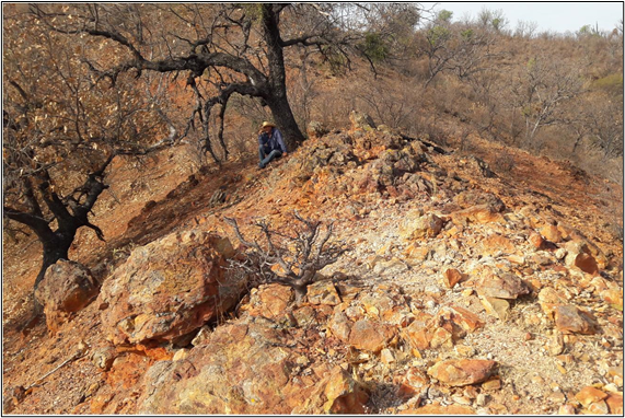
Figure 1. Moderate rolling topography on Diamante 1 showing extensive oxidation, jarosite and argillic alteration at the El Caso showing.
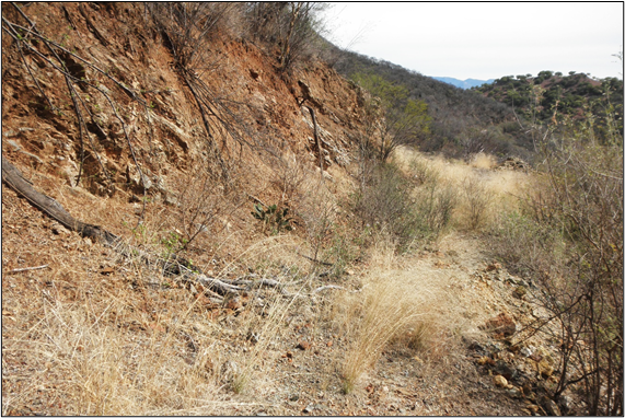
The Company retained Eagle Mapping Ltd. ("Eagle Mapping") to carry out a LiDAR (Light Detection and Ranging) survey over the Property. As shown in Figures 1 and 2, the Property mainly exhibits moderate topographic relief over many areas of the known mineralization.
Eagle Mapping collected LiDAR data and aerial photography from a nominal flight elevation of 5000 feet (1500 metres) at a minimum density of 8 ppm (pulses/m2) with expected accuracies of ±15 cm in the vertical and ±30 cm in the horizontal. Colour aerial photography will be orthorectified to the LiDAR base earth model with a 12 cm pixel resolution. Digital elevation (DEM) and digital surface (DSM) models with contours at 1 metre will be generated. The LASer (LAS) point cloud with classified bare earth and metadata final report will be contained in the deliverables. The LAS format is an open binary file format designed for the interchange and archiving of LiDAR point cloud data and regarded as an industry standard for LiDAR data.
The Eagle Mapping team mobilized from Mexico City with a local flight base from Ciudad Obregón, southern Sonora, Mexico. Our LiDAR survey results are scheduled to be processed and reported shortly.

Figure 2. Steep outcrop exposure cut along historical trail on Diamante 1 near La Prieta artisanal mine.
About Eagle Mapping
Eagle Mapping has more than 30 years of Aerial Mapping experience and flown LiDAR surveys from Alaska to Chile for clients associated with Mining, Forestry, Engineering, Ecological and First Nations sectors. They specialize in Aerial LiDAR and air photo collection and processing, and own state of the art LiDAR collection equipment including the RIEGL VQ-780i, LMS-Q1560 and LMS-Q780 using the most sophisticated software to process LiDAR data.
Project Background
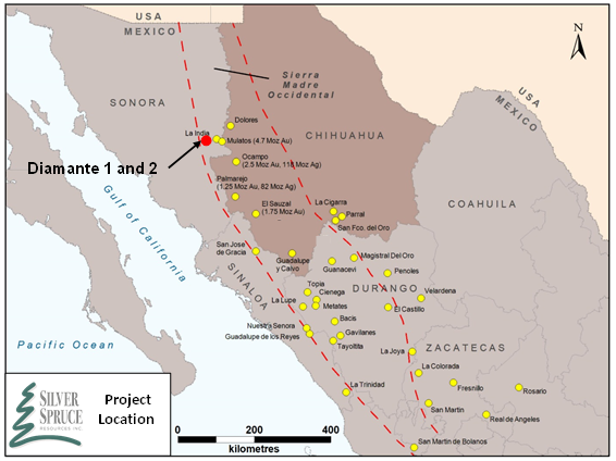
The Property is located within the west-central portion of the Sierra Madre Occidental Volcanic Complex within the prominent northwest-trending "Sonora Gold Belt" of northern Mexico and parallel to the well-known, precious metals-rich Mojave-Sonora Megashear (Figure 3).

Figure 3. Location Map of Diamante Property and Mines of the Sierra Madre Occidental
The Property is very well situated in terms of logistics for exploration, adjacent to and west of the El Mezquite and Jackie properties, and is located twelve to fifteen kilometres west and northwest of the Nicho deposit currently under mine development by Minera Alamos (see Press Releases - April 26 and April 29, 2021).
The adjacent El Mezquite and Jackie projects are currently subject to option agreements with Colibri wherein SSE can earn 50% of the gold and silver projects by meeting certain criteria over four years and two years, respectively.
El Mezquite and Jackie currently have assays pending from Phase 1 mapping and prospecting while we recently received our SEMARNAT approval for El Mezquite's maiden drilling program to begin this month (see Press Release - April 20, 2021).
Project Geology
Diamante includes more than ten known occurrences at La Prieta-El Aguaje, El Chon-El Pillado, La Olla, La Cruz and El Caso, Mezquite Raizudo, El Puerto, El Cumbro, Calton and the Southern Anomaly (Figure 4). The target locations were provided previously (see Press Release - April 12, 2021).
Sampling highlights on Diamante have reported outstanding values of precious and base metals (Au, Ag, Pb, Zn) collected from historical mine dumps, small-scale processing slag, and assays from vein (veta) and stockwork style mineralization to 39.8 g/t Au and 3,460 g/t Ag with significant base metals (see Press Releases - April 12 and April 26, 2021).
The Property exhibits geological features of epithermal low to intermediate sulphidation Ag-Au (Pb-Zn), high sulphidation Au-Cu, and potential transition to porphyry style Au-Cu.

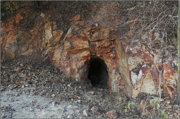
Figure 4. Sampling (channel 0.3 metres) to right of 1.5metre wide adit, silicified breccia, N30°E fracturing filled with quartz and sulphides, El Chon artisanal workings on Diamante 1.
Qualified Person
Greg Davison, PGeo, Silver Spruce VP Exploration and Director, is the Company's internal Qualified Person for the Diamante Project and is responsible for approval of the technical content of this press release within the meaning of National Instrument 43-101 Standards of Disclosure for Mineral Projects ("NI 43-101"), under TSX guidelines.
About Silver Spruce Resources Inc.
Silver Spruce Resources Inc. is a Canadian junior exploration company which has signed Definitive Agreements to acquire 100% of the Melchett Lake Zn-Au-Ag project in northern Ontario, and with Colibri Resource Corp. in Sonora, Mexico, to acquire 50% interest in Yaque Minerales S.A de C.V. holding the El Mezquite Au project, a drill-ready precious metal project, and up to 50% interest in each of Colibri's early stage Jackie Au and Diamante Au-Ag projects, with the three properties located from 5 kilometres to 15 kilometres northwest from Minera Alamos's Nicho deposit, respectively. The Company also is pursuing exploration of the drill-ready and fully permitted Pino de Plata Ag project, located 15 kilometres west of Coeur Mining's Palmarejo Mine, in western Chihuahua, Mexico. Silver Spruce Resources Inc. continues to investigate opportunities that Management has identified or that have been presented to the Company for consideration.
Contact:
Silver Spruce Resources Inc.
Greg Davison, PGeo, Vice-President Exploration and Director
(250) 521-0444
gdavison@silverspruceresources.com
Michael Kinley, CEO
(902) 826-1579
mkinley@silverspruceresources.com
info@silverspruceresources.com www.silverspruceresources.com
Neither TSX Venture Exchange nor its Regulation Services Provider (as that term is defined in the policies of the TSX Venture Exchange) accepts responsibility for the adequacy or accuracy of this release.
Notice Regarding Forward-Looking Statements
This news release contains "forward-looking statements," Statements in this press release which are not purely historical are forward-looking statements and include any statements regarding beliefs, plans, expectations or intentions regarding the future, including but not limited to, statements regarding the private placement.
Actual results could differ from those projected in any forward-looking statements due to numerous factors. Such factors include, among others, the inherent uncertainties associated with mineral exploration and difficulties associated with obtaining financing on acceptable terms. We are not in control of metals prices and these could vary to make development uneconomic. These forward-looking statements are made as of the date of this news release, and we assume no obligation to update the forward-looking statements, or to update the reasons why actual results could differ from those projected in the forward-looking statements. Although we believe that the beliefs, plans, expectations and intentions contained in this press release are reasonable, there can be no assurance that such beliefs, plans, expectations or intentions will prove to be accurate.
SOURCE: Silver Spruce Resources Inc.
View source version on accesswire.com:
https://www.accesswire.com/643817/Silver-Spruce-engages-Eagle-Mapping-for-LiDAR-Survey-on-Diamante-Au-Ag-Project-Sonora-Mexico


